In the original Meath County Council Planning report (file 01/4014, dated 9/3/2001, approved 13/3/2001) the following text is found (section 3.6 page 28):
“Visible plume formation associated with the emission stack particularly in the periods of cold weather will be reduced as it is proposed to heat exhaust gases to 100°C.”
This statement is left out in the final version of the Planning report (July 31st, 2001)!
The terms reduced and proposed need more body, certainly because the visible plume (clouds) could block the winter solstice sun which goes into Newgrange. It is recommended that a study will be performed to determine cloud formation due to the Indaver incinerator and if these clouds could block the sun light presumed to go into Newgrange.
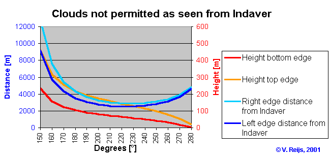
Clouds are not permitted to be formed around winter solstice at the following sky window:

(Height = 0m is the height of the incinerator's chimney outlet)
Useful models could be Seasonal/Annual Cooling Tower Impact (SACTI: http://www.ead.anl.gov/ead/who/section/ats.cfm) and Combustion Stack Visible Plume (CSVP).
Prof. Perry J. Samson, University of Michigan states:
“If the relative humidity is relatively high then there is a reasonable
change the plume will persist for some distance downwind. Qualitatively
the higher the relative humidity the long the plume will persist and effect
sunlight.”
Dúchas has mentioned this already in their reaction towards Meath County Council on July 23rd, 2001:
"... in relation to the visual impact of the 40m chimney stack. We would ask that its potential visual impact on the Boyne Valley area site included in the UNESCO World Heritage list, be taken into consideration in the decision on weather or not planning should be granted for this development."
I have not seen official feedback or to Dúchas or within the final Meath County Council Planning report (July 31st, 2001). An official investigation if UNESCO (http://www.unesco.org/whc/archive/opguide99.pdf) approves this building, is recommended.
Donore is 2.5 km from the Indaver incinerator and at a height of 70 m above sea level (so almost at the same height as the chimney outlet, see also View 22 of EIS attachments). The model used by Indaver Ireland (Industrial Source Complex Short Term, ISC3 ST) supports a more complex terrain than a flat ground (called Terrain Grid pathway, see ISC3 User’s Guide, Volume 1: http://www.epa.gov/scram001/userg/regmod/isc3v1.pdf section 3.6). A recalculation of the ground level concentrations including this Terrain Grid pathway is recommended.