 Home
Home Up
Up Search
 Mail
Mail
NEW
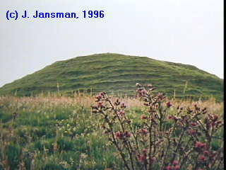
Maeshowe
The megalithic mound
The passage
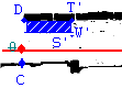
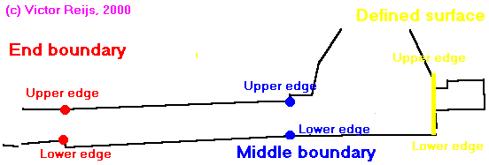
A lot of measurements have been done to check the maps provided within
the booklet of Ashmore, P. (1995,
page 6).
It looks like that the overview and the
crosscut (both derived from Crown Copyright:RCAHMS material) are accurate
enough. More precise measurements of important points in the passage can
be seen in the below table (where the cross point between C-D and the line
M is taken as the origin of the grid, point 0):
| Point |
X |
Y |
Z |
|
[cm] |
[cm] |
[cm] |
| C |
0 |
-15+/-1.5 |
-29+/-0.7 |
| D |
0 |
56.5+/-0.3 |
91.5+/-0.7 |
| S |
179.5+/-0.2 |
-0.4+/-0.2 |
0 |
| T |
179.5+/-0.2 |
69.8+/-0.3 |
0 |
| W' |
179.5+/-0.2 |
-1.2+/-0.1 |
46+/-0.7 |
| T' |
179.5+/-0.2 |
-1.2+/-0.1 |
91.5+/-0.7 |
| E |
391.5+/-0.3 |
0 |
0 |
| G1 |
948.5+/-0.7 |
0 |
0 |
| H1 |
948.5+/-0.7 |
72+/-0.7 |
0 |
| G2 |
1013.5+/-0.8 |
-7.2+/-0.1 |
0 |
| H2 |
1013.5+/-0.8 |
68.8+/-0.3 |
0 |
| U |
1579.5+/-1 |
0 |
0 |
| I |
1579.5+/-1 |
-32.5+/-0.3 |
0 |
| K |
1579.5+/-1 |
53+/-0.3 |
0 |
| J |
1579.5+/-1 |
117+/-0.3 |
0 |
These can thus be used to make a model.
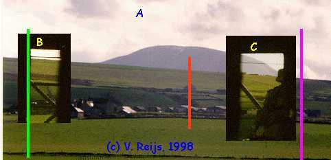
Three lines are important in the overview:
-
line A (green)
This is the most southern azimuth of 215o 15' +/- 5'.
-
line M (red)
This is the line that will be taken as the x-reference plane for making
the model. Its azimuth is 219o 40' +/-
15'
-
line B (purple)
This line is the most northern azimuth of 222o 57' +/- 5'
The azimuths are determined by:
-
line A: by means of watching the first light
on back wall on December 21st, 1997 at 14:46 GMT,
-
line M by means of the differences of azimagn
with regard to line A
-
line B: by means of watching the last light
on back wall on January 12th, 1998 at 15:31 GMT.
The above azimuths are also caused by a bend in the passage. Such a bend
in the passage can also been seen at Wideford
Hill.
In Ashmore, P, 1995 the azimuth of line B is: 217o (error
unknown).
These lines can also be seen on a picture of the horizon (for a panorama
pictures, click here). The altitude of the
horizon at the line A is 1o20' +/- 5'.
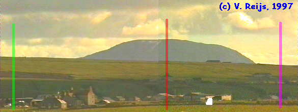
The Barnhouse stone is enhanced in the above mentioned picture
by white contours. The azimuth of this stone is around 221o
5' +/- 15' and its altitude around -0°11' +/- 5' on a distance of 800
[m].
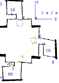
The four blocking stones
There are four blocking stones within Maeshowe.
Below first the dimensions of the entrances (starting from the down-horizontal
side and then CCW):
-
Left Recess (LR)
Dimension of opening: 72 x 77 x 71 x 77 [cm]
height from floor: 74 [cm]
-
Center Recess (CR)
Dimension of opening: 62 x 75 x 58.5 x 76.5 [cm]
height from floor: 85 [cm]
-
Right Recess (RR)
Dimension of opening: 73 x 86 x 70.5 x 86 [cm]
height from floor: 74 [cm]
-
Passage entrance (ST)
Dimension of opening: 100 x 100 x 100 x 100 [cm]
height from floor: 0 [cm]
The four blocking stones for these entrances/recesses are:
-
Blocking stone 1
Now laying near: LR (but does not have to belong to this recess!)
front view: 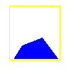
thickness: 54 [cm]
-
Blocking stone 2
Now laying near: CR (but does not have to belong to this recess!)
front view: 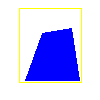
thickness: 57 [cm]
-
Blocking stone 3
Now laying near: RR (but does not have to belong to this recess!)
front view: 
thickness: 42 [cm]
-
Blocking stone 4
Now laying near: ST
front view: 
thickness: 82 [cm]
The thickness on the right (close to the point S) is 82 [cm], on the
left side the stone is thinner. This has not been measured (so to be done
in future!).
The white squares are 100 x 100 [cm]. The yellow lines give the approximate
contours of the recess entrance that is (now) closest to the stone.
Remember: the orientation of the stones could be different in the
past of course then pictured now!
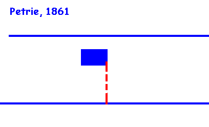
Passage entrance and its blocking stone
From Davidson and Henschall (1989)
can be read that the environment of the entrance blocking stone was different
in 1861 than now.
It seems that it was rebuild with a higher roof. According to Gibb,
the height of the passage was then 70 cm, if the floor was raised or not,
is not really known. I assume that the door-check, which
is 88 cm in height, was the original height of the entrance passage. This
results in a height of the entrance (W') of 46 [cm] with regard to the
reference grid.
The top of blocking stone is at 46 [cm] in the reference grid (S').
(This will have to be verified by means of a mock-up. At this moment
it looks like that the left side of the blocking stone [at the present
location] is at the same height as the right side of the door check,
but on the left side of the blocking stone is some 5 [cm] lower,
so still a possibility of a gap).
An animated picture of ideas around the passage blocking stone is made
(see below). These pictures has been derived from plans of the mentioned
author in the picture. The height of the inner passage has been equaliized
over all maps. The height of the passage blocking stone (in red)
has been drawn as mentioned in their papers (sometimes this does not match
the real height of the blocking stone).
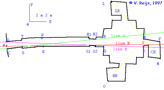
Relation between recesses
From the general overview picture one could
deduct that the lines MKL and KO are straight lines. But if one does measurements
inside the building it looks a little bit different. No effort is putten
in making a new overview (because one should need much more information),
but some lines are measured. The line identification can be found in the
below picture:
The following has been measured:
-
line through K and 5
ends exactly on O
-
line through M and 4
ends at 1y-14 [cm]
-
line through M and K
ends at 2x+7.5 [cm]
-
line through M and 1
ends at Ly-26 [cm]
-
line through K and 2
ends at Lx+10 [cm]
Light path within Maeshowe
At winter solstice the sun shines within the passage and chamber. At present,
the sun beam is getting in at winter solstice day, to the left and down
of the center recess (CC). See also the picture,
which has been made around winter solstice.
A calculation model of Maeshowe has been made,
using the measurements mentioned on this and other
page. This model has been used to calculate the below simulated light patches
in 1996 CE and 2800 BCE.
Simulated light patch at 1996 CE
In the below table one sees how long the sun will shine in the chamber
on
the back wall at 1996 CE on the days before/after winter solstice (220o
55' on December 21, 1996):
| |
1st light
|
|
2nd light
|
|
|
Day
|
first
|
last
|
first
|
last
|
|
before/after
|
minute
|
minute
|
minute
|
minute
|
|
solstice
|
before
|
before
|
before
|
before
|
| |
sunset
|
sunset
|
sunset
|
sunset
|
|
0
|
28
|
17
|
|
5
|
29
|
18
|
|
10
|
33
|
20
|
|
18
|
44
|
24
|
|
19
|
47
|
24
|
11
|
11
|
|
20
|
48
|
23
|
15
|
11
|
|
21
|
50
|
12
|
|
25
|
54
|
21
|
|
30
|
54
|
31
|
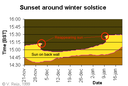
Remark: This is calculated as the passage is now
(so with higher passage roof and no blocking stone) (photo's
made from the back wall of the chamber towards the outside).
Based on my ideas, the custodians of Maeshowe watched the sunsettings
in 1996 en 1997. At last the reappearing of the sun behind Ward Hill has
been seen by the custodians of Maeshowe on Dec. 2nd, 1997.
Videos
and pictures have been made in Dec. 1998.
The reappearing of the sun light at 20 days before/after
winter solstice and from 48 to 11 minutes before sunset is simulated with
an
animated picture (2 pictures per minute). The size and location of
several corners of this animated picture related to the referance grid
are:
|
corner location
|
X
|
Y
|
Z
|
| left down |
1579,5 |
130 |
0 |
| right down |
1579,5 |
-50 |
0 |
| right up |
1579,5 |
-50 |
80 |
| left up |
1579,5 |
130 |
80 |
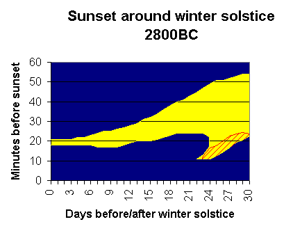
Simulated light patch at 2800 BCE
In the below table one sees how long the sun will shine in the chamber
on
the back wall at 2800 BCE on the days before/after winter solstice (219o
20' on January 13, -2799):
|
1st light |
|
2nd light |
|
| Day |
first |
last |
first |
last |
| before/after |
minute |
minute |
minute |
minute |
|
before |
before |
before |
before |
| solstice |
sunset |
sunset |
sunset |
sunset |
| 0 |
21 |
18 |
| 5 |
22 |
18 |
| 10 |
26 |
17 |
| 15 |
32 |
20 |
| 20 |
41 |
24 |
| 22 |
45 |
24 |
| 23 |
47 |
24 |
13 |
11 |
| 24 |
49 |
22 |
18 |
11 |
| 25 |
51 |
13 |
| 30 |
54 |
23 |
Remark: Around 23 days before and after winter solstice sunset the sun
reappears in the same fashion as now a days. Remember
this 22/23 days could be an important period, because this was in (pre?)historic
times a month.
In the following picture one can see the moments the sun is on the back
wall around winter solstice (when no passage blocking stone is in place:
the yellow gives an idea when the sun shines through the present entrance
or the entrance of Petrie/Burl, the red shaded part gives an idea when
the sun will shine on the back wall if the height of the entrance is as
presented by Gibb/Reijs):
Conclusions
Looking at the data found on this page, it seems that Maeshowe had not
one but two alignments! One alignment at winter solstice sunset
and one a (pre?)historic month (22/23 days) earlier. If both of
the aligments were really used (perhaps only the 23 days alignment could
have been used), is difficult to determined (yet).
Other links:
Disclaimer and Copyright
HomeUpSearchMail

Major content related changes: |Dec. 22, 1999