 Home
Home  Up
Up  Search
  Mail
NEW
Wideford Hill
This chambered mound is some 9.5 km east
of Maeshowe, build on the west
flank of the Wideford Hill mountain. The mound is restored in such a way
that not all mound material has been putten back. That is why some internal
structures (the walls) can been seen.
This type of internal structure is also found at
Maeshowe. Another thing that can been seen at Maeshowe and Wideford Hill
is that the passage ways of both buildings are somewhat bend. The differance
is that the bend at Wideford Hill is in the differant direction.
The passage way
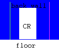
The azimuths measured at Wideford Hill are (using method magn-true north5):
-
the most southern light path (green line)
267o 45' +/- 15'
-
the most northern light path (purple line)
277o 45' +/- 15'
The altitude of the horizon is -15' +/- 5'
The light patch on the back wall of the chamber could be as follows:

The picture is 120 [cm] long and 100 [cm] high.
Henshall (Part I, 1963) provides an azimuth
of around 270o, accuracy unknown.
Sun shining in at equinox
Looking at the azimuth of the passage, it seems that Wideford Hill is aligned
to equinox sunset (March 21 or September 23).
Using a program to calculate the position of the sun, it looks that
the sun will shine in from March 18 until March 29 (or Sept. 15 until Sept.
26) around 18:30 local time. All of this are approximate values!!!
The hole under the capstone
It seems that the top of the chamber has been rebuild, so it is not
really original. The question is thus if the below is still valid!
The dimension of the hole under the capstone is 100 [cm] by 45 [cm].
The azimuth of the long side of the hole is 172o 45' +/- 15.
The height from the present floor level is 238 +/- 1 [cm] and one long
side of the hole is some 20 cm from the back wall and above the centre
recess (CR).
According to Henshall (Part I, 1963) the azimuth
is around 173o, accuracy unknown.
Disclaimer and Copyright
 Home
Home  Up
Up  Search
  Mail
Mail
Last major content related changes: February 9, 1997
