Home
Home Up
Up Search
 Mail
Mail
NEW
Some evaluation of measurements at Dowth
Direction of Newgrange seen from Dowth
Based on GPS measurements and relating
it to
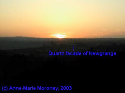
a picture made by Anne-Marie Moroney of the last glimpse of the Sun on
Nov. 20th
2003 16:19 UTC, it looks like that the entrance
of Newgrange is seen
around
237.5° from the southern side of the top of Dowth.
Remember that this direction can vary with +/- 0.25°
depending on where one stands at Dowth (on southern side of the top,
the center of Dowth, entrance Dowth North,
entrance Dowth South). This change is considerable because Newgrange is
relatively close by (only 1900 m).
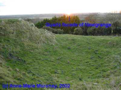
Anne-Marie Moroney also made a picture from the eastern side of the top
on Nov 16th, 2002.
Here the last glimpse of the Sun was more to the center and entrance of
Newgrange.
Minor standstill limit direction at Dowth
According to Brennan ([1983], page 70),
the centre of Newgrange is aligned with lunar minor standstill limit
seen from the centre of Dowth.
The last glimpse of the Sun on Nov. 19th 2003 CE is at the
same azimuth and apparent altitude as the last glimpse of the Moon at
minor standstill limit events around 3200 BCE
(236.4°). So this is some 2 Moon/Sun widths from the Newgrange
entrance. From the centre of
Dowth to the centre of Newgrange the direction is 238.2°.
If one assumes an error 0.5° to be
possible with neolithic alignment, then there is a quite small
possibility
that Newgrange and Dowth are aligned (or it must have been more a
symbolic direction).
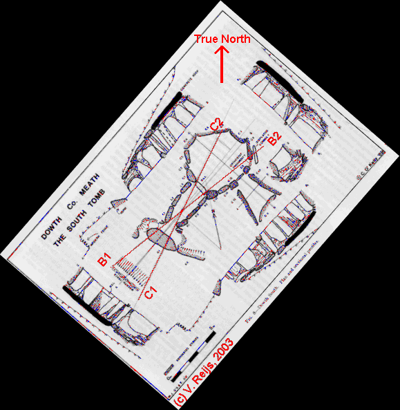
The directions of the Dowth passages
The reference axis magnetic azimuth measured in
1969 by O'Kelly
[O'Kelly, 1983, page 151 and 157) at
Dowth
are: Dowth North 250°
and Dowth South: 234°. Other measurements have been taken in June
2001 with a compass [Prendergast and Ray, 2002]
and gives an azimuth for Dowth South of 217° for their reference
axis. This should
have been an azimuth of 218.4° if using his magnetic azimuth
(224.5°, June 2001) and the magnetic declination [pers.
comm. Prendergast, 2003].
The difference (15.6°) between Prendergast and O'Kelly is not only
the difference between
magnetic and
true north (which was around
11° for the O'Kelly measurement), but at least also because both
use a different reference axis
for
the passage.
Dowth South
Based on the magnetic measurements done by Prendergast & Ray [pers.
comm. Prendergast, 2003] the
following data can be deducted for Dowth South: sky window:
azimuth: 207.6° (original magnetic azimuth C1-C2 from pers.
comm. Prendergast, 2003) to 231.4° (original magnetic azimuth
B1-B2 from pers.
comm. Prendergast, 2003) and
apparent altitude: 0.33° to 7.25°. Giving a likely
average
azimuth (+/- 0.5°) of sky window
of: 219.5° for Dowth South.
Because of the
difference in reference axis defined by the two authors, the magnetic
readings of
both of them are comparable (within 0.5°, which is within error
boundaries of compass reading).
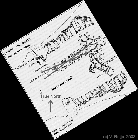
Dowth North
The reference axis
(an estimated for the average axis) by Prendergast&Ray [pers. comm.
Prendergast, 2003] of Dowth North
is 245.9°. This is some 6.9° off from O'Kelly measurement
of their reference axis (239°=250° - 11°). Because
Prendergast&Ray is only an
estimate of the average axis, the O'Kelly measurements sound more
substantial due to her defined reference axis: 239°. Using the
reference axis of O'Kelly one gets
a possible sky
window:
azimuth: 232.8° to 246.6° and apparent altitude: 0.33° to
6.5°. With a likely average azimuth (+/- 0.5°) of the sky
window of 239.7°.
Perhaps a re-measurement of this passage needs to be done, due to the
big difference of the Prendergast&Ray and O'Kelly measurements.
Disclaimer and Copyright
HomeUpSearchMail
Major content related changes: Dec 1, 2003