Megalithic Month alignment
at Maeshowe
by
The Netherlands
1 Introduction
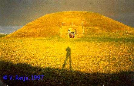
Maeshowe is one of the biggest and best preserved chambered cairns
in Orkney, up north of Scotland. It was build around 3000 BCE and is at
least aligned with the sunset of winter solstice day. But another
orientation
is presented in this paper. This paper will reveal the path of
discovering
a Megalithic Month alignment of Maeshowe; after first providing the history
on this discovery, the ideas how to model a
megalithic
buildings are presented. The conclusions
of comparing this (computer) model with reality are given in the
evaluation
section. And at the end of the paper, the future
steps
will be revealed, because there are of course still more things to be
discovered!
2 History
The history of my discovering a new orientation at Maeshowe started
with
an Internet friendship with Doug Schwartz in 1995. He stated that Maes
Howe was probably not a winter solstice building, but a Yule building,
which meant that it was aligned to a period before and after winter
solstice
and thus not the solstice itself. With his help and a recommendation
letter
from Euan MacKie, I got permission from Historic
Scotland to make measurements in August 1996 within Maeshowe. These
measurements were accurate enough to base a computer model on. From
this
model it became instantly clear that the passage and chamber were
certainly
not aligned to winter solstice day only, but for at least a period of
some
30 days before and after winter solstice day the sun would penetrate
towards
the back wall of the chamber. This long period of sun on the back wall
of Maeshowe was communicated to the custodians of Maeshowe, and they
started observations in Nov., Dec. 1996 and Jan. 1997. These
observations
brought to light that indeed light was seen as early as mid Nov. on the
back wall!
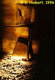
Sunset on 15:03 GMT, Nov. 23rd, 1996 (©, S. Hodnett,
1996)
Because this unique information was never before so clear, more
study
has been done. In May 1997 a new visit was made. During this visit it
became
clear that there was a possibility of a reappearance of the sun behind
Ward Hill (analogous to the reappearance of the moon at Callanish I in
Lewis, Scotland [Ponting]). This
reappearance
was not recognized earlier, because during my Aug. 1996 visit too much
haze obscured Ward Hill from view!
Incorporating this information in the computer model, the reappearing
sunlight will be seen on the back wall some 22/23 days before and after
winter solstice day 2800 BCE. This 22/23 day period is called a
Megalithic
Month (MM, or 1/16th of a year) by [Thom].
To film this phenomenon the custodians of Maeshowe were asked to
note
more precisely the sunsets and possible reappearance's in Nov. and Dec.
1997. As expected, on Dec.2, 1997, the sun was seen reappearing from
behind
Ward Hill and shining on the back wall, thus proving the computer
model.
In Dec. 1997 and Jan. 1998 a video camera continuously recorded the
sunsets
within the Maeshowe chamber [Reijs-c], this
provided
more accurate information for the computer model. Unfortunately, no
reappearing
sunlight on the back wall has been video taped due to bad weather in
Jan.
1998.
3 Modeling
Before starting to make the model, one has to study and measure in the
field. This section will provide some insight into the tools used and
how
the basic measurement were transformed into a model of Maeshowe.
3.1 Tools
The tools used to make the model for predicting the alignments at Maes
Howe, can be subdivided in the following items:
-
Measurements tools
Basic equipment used are: a compass (determine the azimuth), a laser
pointer (determination of straight lines), a water level (to determine
the horizontal level) and the sun (for azimuth calculations).
- Recording equipment
Photo and video equipment has been used to record many features of
the building and surroundings (altitude of horizon, azimuth and
situation
pictures)
- Other tools
Ordnance Survey maps of the
Maeshowe environment, literature on the subject Maeshowe (see Reference
section) and a planetarium computer program (SkyMap)
are extensively used.
3.2 Model
The following items are determined to make a valid model of a
building:
-
A plan and section of the building
Beside defining a reference grid in the
monument
(line M), a global idea of the building can be seen in the plan and
section
made by Calder, 1946:
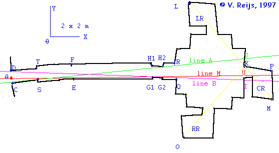
Plan of Maeshowe
Section of Maeshowe
- The minimum and maximum azimuth at which the sun will shine on
the back
wall of the chamber.
These minimum and maximum azimuth (respectively: line A and line B)
are determined by four stone slabs in the passage. The measured
positions
of these horizontal limiting stone slabs are used within the computer
model.
The actual azimuth of these lines is
determined
by using several tools:
|
Tool
|
Azimuthmin
Line A
|
Azimuthmax
Line B
|
|
Compass
|
218°
|
227°
|
|
OS map/pictures
|
217°
|
223°
|
|
Sun's rim
|
215°15'
|
222°57'
|
There is yet no other literature that provides information on these two
lines. Most of the time one finds in literature only an average of
these
two lines, which does not say much for celestial alignments!
In [MacKie] azimuth measurements by
theodolite
have been done of the right and left hand slope of Ward Hill. Comparing
this with my measurements:
Slope of
Ward Hill
|
[MacKie]
Theodolite
|
[Reijs]
Sun's rim
|
| Left |
216° 59' |
217° 19' +/- 10' |
| Right |
222° 53' |
222° 29' +/- 10' |
These values are well within the same neighborhood, so the azimuths
determined by the sun's rim are accurate, and are used in the
model.
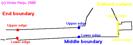
- The position of the vertical limiting
stones
Several cases from the literature are evaluated:
-
Petrie, 1861
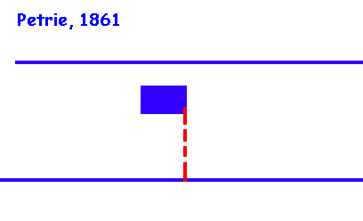 A high entrance, at
the
height of the passage blocking stone a horizontal stone.
A high entrance, at
the
height of the passage blocking stone a horizontal stone.
- Gibb, 1862
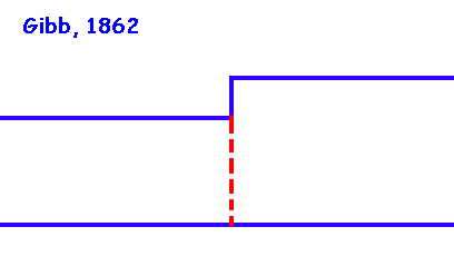 A low entrance,
fully blocked
by the passage blocking stone
A low entrance,
fully blocked
by the passage blocking stone
- Calder, 1946
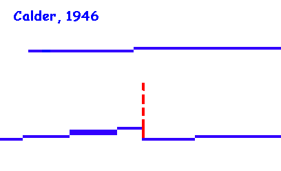 The
present
situation, with a high entrance.
The
present
situation, with a high entrance.
- Burl, 1981
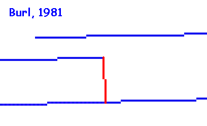 A
high entrance
at the height of the passage blocking stone, a horizontal slab (similar
to the roof box at Newgrange). Partially
comparable
with Petrie.
A
high entrance
at the height of the passage blocking stone, a horizontal slab (similar
to the roof box at Newgrange). Partially
comparable
with Petrie.
- Reijs, 1997
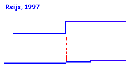 A low entrance
almost blocked
by the passage blocking stone, where a gap of some 2-6 [cm] still
exists.
Partially comparable with Gibb.
A low entrance
almost blocked
by the passage blocking stone, where a gap of some 2-6 [cm] still
exists.
Partially comparable with Gibb.
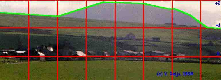
-
The altitude of the horizon
The altitude has been determined by photographic measurements. A
picture
has been made of the horizon. This picture has been digitized, and the
altitude calculated. In the below pictures, these altitudes are
provided
(y-scale from -1° to +2°):
-
The altitude and azimuth of the sun
This information was obtained from a planetarium computer program (SkyMap,
which incorporates parallax, precession, nutation and astronomical
refraction).
It has been determined for the periods around the dates: Dec. 21st,
1996 CE and Jan.13th, 2799 BCE.
4 Results
Let's first investigate the observations obtained in the present. The
sun
shines on the back wall from at least 30 days before winter solstice to
30 days after winter solstice. A very long time!
At present days: On around 19/20 days before and after winter
solstice
the sun will reappear from behind Ward Hill. (this reappearance is not
a feature of Maeshowe itself, but rather of the local landscape). The
reappearance can be viewed on the back wall. Because of this dynamic
process
of reappearance, a video would be needed to show how it is seen on the
back wall of the chamber. Because no video recordings are yet available
for sunny days, an animated picture has been made with the computer
model
[Reijs-a].
The computer model of Maeshowe is accurate within +/- 1 [minutes of
time] and +/- 2 [cm] for determining the timing and location of the
sunlight
on the back wall of the Maeshowe chamber.
Using the computer model for 2800 BCE, the following information on
when the sun will shine on the back wall (depending on the vertical
limiting
stones, see section: Model) is determined:
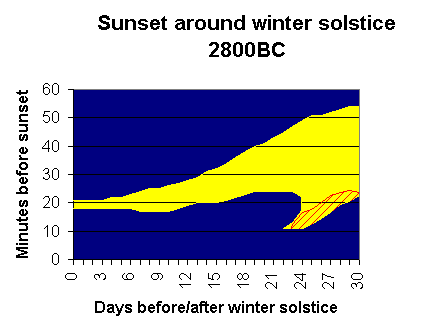
The reappearance of the sun behind Ward Hill occurred in 2800 BCE
around
22/23 days before/after winter solstice. This 22/23 day period is
termed
by many (e.g. [Thom] and [Thomas])
a Megalithic Month (or 1/16th of a year).
The bright and shaded part defines the moments the sunlight will be
on the back wall when using the Petrie or Burl
limiting stones. Thus the sunlight will be on the back wall at winter
solstice
day only for a few minutes. Further away from winter solstice day the
amount
of time increased to 25 minutes at some 21 days before/after winter
solstice.
From 22 to 24 days before/after winter solstice (1 MM) the reappearance
of the sun takes place: the sunlight is some 25 minutes on the back
wall,
then it disappears behind Ward Hill (and thus no light is in the
chamber)
and then that a short flash of light on the back wall. After these
days,
the sunlight will be on the back wall again in one go and will vanish
fully
from the back wall after more then 30 days.
The shaded area is depicting the moments that the sunlight will be
on
the back wall using the Gibb or Reijs limiting
stones. The difference between Gibb and Reijs is that in Gibb there
will
only be sunlight on the back wall, when the passage blocking stone is
in
its recess (remember in this case there will always be much sun on the
floor of the chamber and in passage on other days). With the Reijs's
limiting
stones there will only be light on the back wall during this shaded
period
and never in/on the passage/chamber. In both cases the reappearing
sunlight
around 22/23 days (1 MM) before/after winter solstice is seen on the
back
wall.
5 Conclusions
The major conclusions to be deducted from the above results are:
-
Some uncertainties with regard to the possible rebuilding of the first
part of passage still exist.
After the excavation in 1861 [Petrie], the first
part of the passage was rebuilt. This idea also stems from the difference
in the plans of Maeshowe made by Petrie and Gibb. Petrie provides
a plan as if there is a kind of roof box above the entrance, while Gibb
draws this as a lower ceiling. The truth will never be known (even
things
from less then 150 years ago are vague).
The bend in the passage is almost unquestionable original. The nice
thing about this bend is that the bend itself had no effect on the
alignment
of winter solstice day at all, but it makes the alignment for 22/23
days
before/after winter solstice much more accurate.
- The computer model more of Maeshowe predicts the light patch on
the back
wall accurately.
The model is able to predict the timing and location of the light patch
on the back wall within +/- 1 min and +/- 2 cm respectively. This gives
confidence in using the model to make predictions in both the past and
present.
Remember the model of the building does not determine the reappearance
of the sun; that is determined by the path of the sun and the local
landscape
(the azimuth of Ward Hill's slope and the altitude of the low hill some
2.5 km south of Maeshowe).
A 3D model of Maeshowe and a
3D terrain of the land strip between the two lakes: Loch of Stenness
and
Loch of Harray related to Hoy [Reijs-b] has
been made, so that one is able to fly thought this virtual world.
- An aperture between passage blocking stone and passage ceiling,
makes a
dramatic sunset around one Megalithic Month before/after winter
solstice.
From simple measurements there is a small gap [some 5 cm] between the
passage blocking stone and the lower ceiling (lowered according to
Gibb).
If this gap was indeed on purpose (see Future steps
section),
the light effects within the chamber is much more dramatic when the
passage
blocking stone closed the entrance. A small patch of bright light would
have penetrated only around 22 to 30 days before/after winter solstice.
- Dual alignments at passage mounds are more common.
Beside Maeshowe, other buildings have also more then one alignment.
For instance, measurements at Newgrange
and Knowth (both in Ireland), show
that, beside light through the passage, also light during midday of the
longest day can penetrate through a hole below the capstone of the
corbelled
roofs!
- Looking at the simulation of the light patch
on
the back wall around 2800 BCE, Maeshowe could very well be a
'Megalithic
Month' building beside a 'Winter Solstice' building.
6 Future steps
Lots of things have been learned during the two years of
investigations,
but more needs to be done.
The following items will be taken up during my next visit to Orkney
in the winter of 1998:
-
Videotape the reappearance's of the sun behind Ward Hill (seen from
both
the outside and inside of Maeshowe).
-
Make a mock-up of the passage blocking stone and see what the effect
will
be on the light path in passage and chamber.
-
Study the layout of the steep slopes of Ward
Hill (Glen
of Greor) and the Cuilags (Kame of Hoy) and the megalithic
buildings
in Stenness environment. These buildings have been build around the two
reappearance's of the sun at both winter solstice and a Megalithic
Month
before/after winter solstice. The general idea of this reappearance of
the sun is also described in [MacKie].
The below pictures depicts this idea:
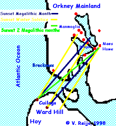
The relationship between steep sloops near Ward Hill and Cuilags and
the buildings near the land strip between Loch of Harray and Loch of
Stenness.
Ward Hill plays a special role! Even in the 18th and 19th
century it radiated magnificent light around the longest day. The
following
quotation from The Pirate (Sir Walter
Scott,
1821) in [Bremner] states:
"At the west of this stone [the Dwarfie Stone] stands an exceeding
high mountain of a steep ascent, called the Ward Hill of Hoy, near the
top of which in the month of May, June and July, about midday
[changed
by VR: in original text midnight], is seen something which
shines
and sparkles admirably, and which is often seen a long way off. It has
shined more brightly before than it does now, and though many have
climbed
the hill, and attempted to search for it, yet they could find nothing.
The vulgar talk of it as being some sort of enchanted carbuncle, but I
take it rather to be some water, sliding down the face of some smooth
rock,
which, when the sun at times shines, on, the reflection, causeth that
admirable
splendour."
7 Acknowledgments
The list of people that have helped me is long. I would especially like
to thank Doug Schwartz and Euan MacKie, who wrote recommendation
letters
so that Historic Scotland provided me the access to Maeshowe. Many
people,
especially Patrick Ashmore, Sue Hodnett and Moira Moncrieff of Historic
Scotland, have willingly provided support in helping me to make
measurements!
Thanks to the Maeshowe project (a cooperation project between the
author,
Charles Tait and Historic Scotland) it was possible to videotape the
sunsets
in Dec. 1997 and Jan. 1998. Furthermore I want to thank Neil Mortimer
and
Douglas Schwartz for their help in reviewing this paper.
Of course, many thanks to all the unmentioned people who are also in
my mind!
Last, but certainly not least, I want to thank my partner, Joke
Jansman,
for her continuous support of my work. She spent many hours alone,
because
I have an urge to try to decipher a mystical building.
8 References
[Ashmore]
Maeshowe, Ashmore, P., HMSO, Historic Scotland, ISBN 1 900168 06 5,
1995, Edinburgh
[Bremner]
Hoy - The dark enchanted isle, Bremner, J., Bellavista Publications,
1997, ISBN 0 9525350 2 5.
[Burl]
By the light of the cinerary moon: chambered tombs and the astronomy
of death, Burl, A., in Ruggles and Whittle (1981), pp 243 - 274.
[Childe]
Maeshowe, Childe, V.G., Proceedings of the Society of Antiquaries
of Scotland, 88, 1956, page 155-171
[Eogan]
Knowth and the passage tombs of Ireland, Eogan, G., London, Thames
& Hudson, 1986, ISBN 0-500-39023-1
[Frazer]
Antiquities of Stenness parish, Frazer, J. Proceedings of the Orkney
Antiquarian Society, 4, 1925, page 18-22
[Henshall]
The chambered cairns of Orkney, Davidson, J.L., Henshall, A.S.,
Edinburgh
University Press, ISBN 0 85224 547 5, 1989.
[MacKie]
Maeshowe and the winter solstice ceremonial aspects of the Orkney
Grooved
Ware culture, MacKie, E.W., Antiquity 71, June, 1997: 338-59.
[O'Kelly]
Newgrange, O'Kelly, M.J., London, 1982, ISBN 0-500-27371-5
[Petrie]
Notice of the opening of a tumulus in the parish of Stenness on the
mainland of Orkney, Petrie, G., Archaeological Journal, 18, page
353-358,
1861
[Ponting]
Decoding the Callanish complex. Some initial results, Ponting, M. and
G., Article out of B.A.R. 88, 1981; Astronomy and society in Britain
during
the period 4000 - 1500 B.C., editor Ruggles, C.L.N. and Whittle,
A.W.R.,
ISBN 0 86054 130 4, page 63-110
[Reijs-a]
Maeshowe, Reijs, V.M.M., 1997, http://http://www.iol.ie/~geniet/maeshowe/eng/scot10.htm
[Reijs-b]
Maeshowe and its environment in 3D, Reijs, V.M.M., 1998, http://www.iol.ie/~geniet/maeshowe/eng/mhvrml.htm
[Reijs-c]
Megalithic cam-page at Maeshowe, Reijs, V.M.M., 1997, http://www.iol.ie/~geniet/maeshowe/
[Reijs-d]
Maeshowe's Megalithic Month alignment, Reijs, V.M.M., 1998, 3rd Stone,
Oct.-Dec. 1998, page 18-20.
Notice of excavations in the chambered mound of Maeshowe in Orkney,
Stuart, J., Proceedings of the society of Antiquity of Scotland, 5,
page
248-278, 1965
[Thom]
Megalithic sites in Britain, Thom, A., Clarendon
Press, Oxford, 1967
[Thomas]
Irish symbols of 3500 BC, Thomas, N.L., Mercier Press, 1988, ISBN 0
85342 856 5.
Last major content related changes: May 31, 1998