Some remarks on Evert-Jan Laméris workflow
Some remarks on Evert-Jan Laméris
workflow by Victor Reijs
is licensed under CC BY-NC-SA 4.0


Introduction
On this web page EJL workflow [Evert-Jan Laméris, 2005] based on DHM
formula, is discussed. It will look at the background and provide
possible feedback
Several questions are
outstanding, see below purple text. If you have input, please
let me know.
Background
EJL workflow is based on the DHM formula of Werkrgoep Molenbiotoop
[1982]. That formula uses the principles presented in Beljaars
[1979].
The workflow is:
- a point cloud with surface and terrain heights (DSM and DTM)
are downloaded from AHN. Preferrable to
moost recent database.
- the location of the wind mill is determined (using molendatabase).
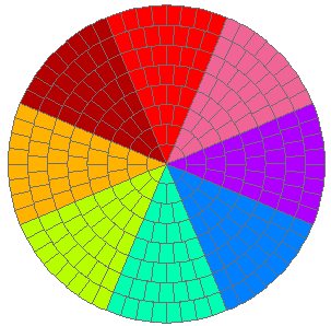
- Divided the area (in 8 rings of 50m wide: total radius of
400m) in 288 sectors (36 sectors in each main wind direction [8
different colors], resulting in 1 to 8 sectors per
ring-segment):
- by using the
standard DHM formule (using n=50 and c=0.2), the HDHM
is calculated
- all HDHM are being normalised by dividing with the
sail-arm length
- the highest normalised HDHM in each sector is
determined. Each sector gets a category allocated (1 to 5),
based on this highest normalised HDHM
- For each of the 8 wind directions, the categories per ring
are summed and weighted averaging has been used to have for each
ring a comprable value.
- All per ring weighted average are summed for each wind
direction, and this indicates the wind obstruction per wind
direction for that mill.
- So all the influences (normalised HDHM) are
evaluted together for the location of the mill (no
interaction between indivudual obstacles).
- In general it is a qualitative methdology (so comparing
between wind mills becomes easier).
Of course different analysis is possible by varying sector
layouting, averaging/summing/weighting and grouping (certainly
because AHN5 has a resolution
of 0.5m). As the database is queried with SQL, these different
analysis can relativly easy be implemented.
Methodology usage
This methodology has been used for all traditional windmills
within some 5 Dutch counties.
Some ideas for extension to the workflow
At this moment the influence of sequence of obstacles is simply
summed. One could of course also use the SpeedFactor (by using
Steve
Temple's method) in the path over all the obstacles
towards the mill in a certain direction. In that way the resulting SpeedFactor is
determined. This should be possible using a proper SQL
querying command.
References
Laméris, Evert-Jan: Ruimte voor Molens met Geo-Informatie.
In: https://onderzoek.molenbiotoop.nl/ (2005), Accessed 7 January,
2025.
Acknowledgements
I would like to thank people, such as Evert-Jan Laméris, and
others for their help, encouragement and/or constructive
feedback. Any remaining errors in methodology or results are my
responsibility of course!!! If you want to provide constructive
feedback, please let me
know.
Major content related
changes: January 7, 2025