NEW
In this page some poor mans methods to determine the aparent
altitude
are discussed. The following methods are discussed:
 One
can
directly
measure apparent altitude with the use of a clinometer, Abney level,
SetRise
Tool® or theodolite.
One
can
directly
measure apparent altitude with the use of a clinometer, Abney level,
SetRise
Tool® or theodolite.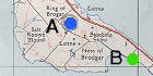 Using
the
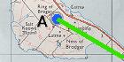
map,
the height difference between two points (A and B) can be
determined.
With this information and the distance between the two points, one
can
determine the apparent altitude by using a formala given by A.
Thom. A web page has
been
made
to calculate the apparent altitude using this method.
Using
the
map,
the height difference between two points (A and B) can be
determined.
With this information and the distance between the two points, one
can
determine the apparent altitude by using a formala given by A.
Thom. A web page has
been
made
to calculate the apparent altitude using this method.
If point B is a vast plain, the formula for the apparent altitude becomes different, see this link.
 One
can
use
a reference object with known position on land (like a top of
house,
meadow rim, etc.) as a means of providing the apparent altitude. The
easiest reference is an object determined by means of a hand
level or Abney
level through which one can determine the zero apparent
altitude
level.
Using then photometry one can determine
the
apparent altitude of the horizon.
One
can
use
a reference object with known position on land (like a top of
house,
meadow rim, etc.) as a means of providing the apparent altitude. The
easiest reference is an object determined by means of a hand
level or Abney
level through which one can determine the zero apparent
altitude
level.
Using then photometry one can determine
the
apparent altitude of the horizon.
 The
shadow
of a celestial body can also be used to determine this (certainly
when
determining the sunniness/mooniness).
One
has to determine the time (use a clock as precise as possible, like
GPS
or NTP) the measurements were done. The apparent altitude of the
sun/moon
can be determined by ephemeris programs
(e.g.
SkyMap
or JPL
ephemeris).
Remember that these programs determine the middle of the celestial
object
and normally the shadow is determined by the top or lower rim of the
object
(for moon and sun this is around 14' difference near the horizon and
16'
difference when they are higher than some 5°).
The
shadow
of a celestial body can also be used to determine this (certainly
when
determining the sunniness/mooniness).
One
has to determine the time (use a clock as precise as possible, like
GPS
or NTP) the measurements were done. The apparent altitude of the
sun/moon
can be determined by ephemeris programs
(e.g.
SkyMap
or JPL
ephemeris).
Remember that these programs determine the middle of the celestial
object
and normally the shadow is determined by the top or lower rim of the
object
(for moon and sun this is around 14' difference near the horizon and
16'
difference when they are higher than some 5°).
 Use
a
good
ground plan of the building (from literature or made yourself).
Remember
that an accurate zero altitude must be provided by this ground plan
(a
good
tool here is a hand
level, a water hose or Abney
level throught which one can look).
Use
a
good
ground plan of the building (from literature or made yourself).
Remember
that an accurate zero altitude must be provided by this ground plan
(a
good
tool here is a hand
level, a water hose or Abney
level throught which one can look).